• Projects
  • About
  • Publications
  • Blog
Menu

ryan b. anderson

Anthropology & Photography
  • Projects
  • About
  • Publications
  • Blog

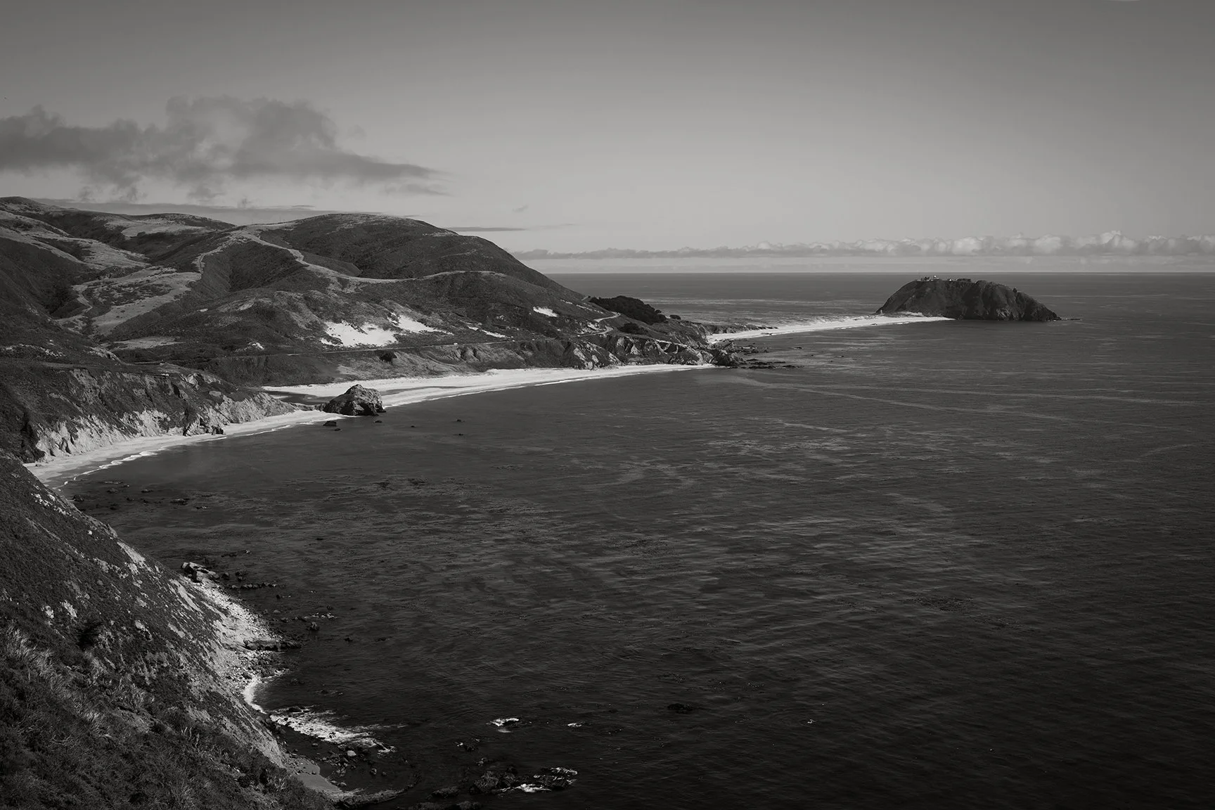
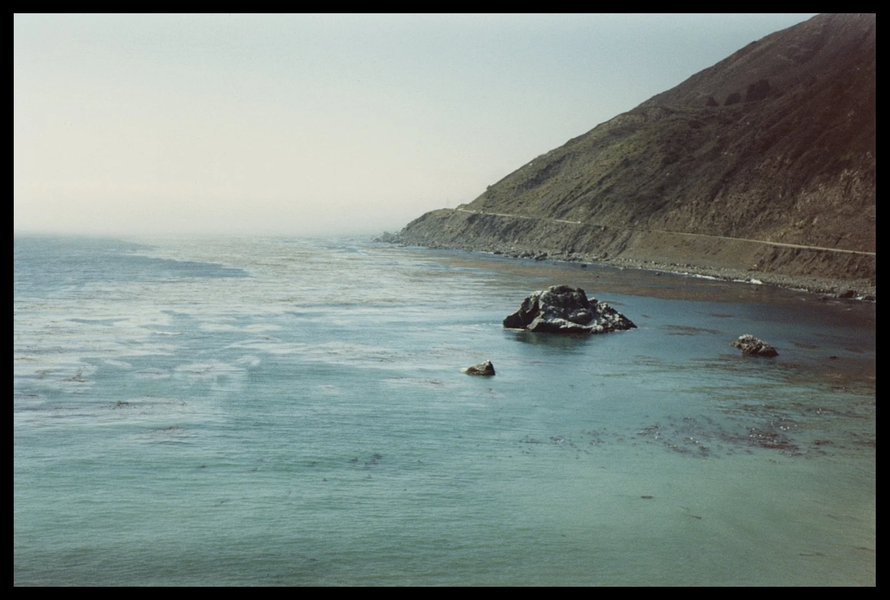
Headland and rocks, Big Sur 1990. Taken from a lookout spot south of Alder Creek. Photo: Ryan B. Anderson.
Big Sur Lookout 1990 (Where it all began)

August 27, 2026

This is the very first photograph that I remember taking in any kind of deliberate sense. I was on a road trip with my mother when I was about 15 years old, so this would have been in 1990. This was taken at a lookout spot just south of Alder Creek. I was using my mother’s Pentax ME-Super with either a 35mm or 50mm lens. This looks more like the 50mm to me. It’s not a particularly sharp image. I was hand-holding the camera and had no idea about things like shutter speed and camera shake. But, looking back, this is basically one photo that I have been basically taking over and over again for decades. Water, headland, coast. Here’s what this spot is looking like more recently, via Google maps:

Read More
In Coastal Anthropology, Photography Tags California, Repeat photography, Big Sur

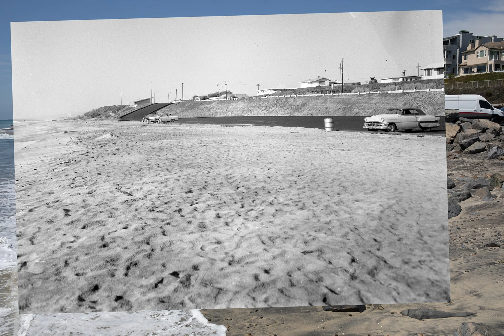
Composite image of the Tamarack Beach parking lot, showing the photograph from 1959 overlaid on the photograph from 2026.

Tamarack Parking lot in 1959 and 2026

August 22, 2026

Here’s another photo from my recent trip down the Southern California. I headed down in part because my old home beach of Tamarack was in the news. Check out some of the coverage via the SF Gate here, and NBC7 here.

Long story short, high tides and large waves from a summer south swell swept a lot of sand off the beach at Tamarack. It also undermined the riprap that was protecting the parking lot. In some of the coverage, people express concern about the loss of sand from the beach. Others say that this is how the beach actually used to look years ago.

Read More
In Coastal Anthropology, Photography Tags Tamarack, Repeat photography, coastal erosion, Coastal engineering, California

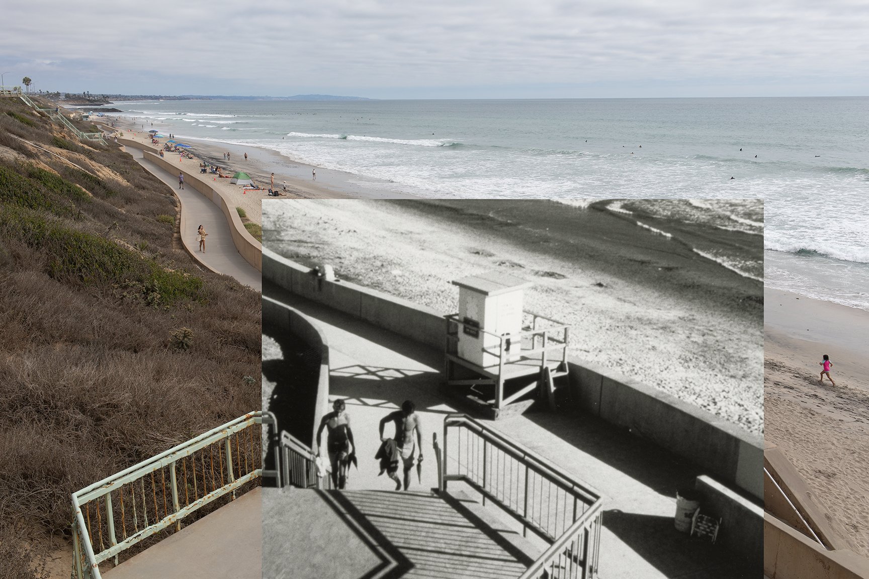
Composite photograph showing an image from 2026 with a black and white inset from the late 1980s to early 1990s.

California Coast Rephotographic Project: Carlsbad Seawall

August 20, 2026

After Tamarack State Beach made the news for losing a bunch of it’s sand in the last couple of weeks, I managed to get down there for a few comparative photographs. The composite above shows a stretch of the seawall that’s at the end of Sycamore Avenue in Carlsbad. This one was pretty easy to relocate and photograph. I found the historical image, which dates to the late 1980s or early 1990s, via the Carlsbad Library:

Read More
In Photography, Coastal Anthropology Tags Seawalls, San Diego County, Carlsbad, Repeat photography

“Near the shore after leaving Oceanside.” Photograph of coastal North San Diego County from the 1880s. From the Huntington Digital Library: https://hdl.huntington.org/digital/collection/p15150coll2/id/12006/rec/7

Near the shore after leaving Oceanside (1888)

November 22, 2025

This is a photograph from the Huntington Digital Archive that I stumbled across while I was working on a recent draft for a paper about the long-term coastal histories of California. I was searching for images of Oceanside, California, which was one of the case studies mentioned in the draft, and I found this one.

It’s from the 1880s. It’s part of a small collection of photographs that someone put together after a trip through parts of Southern California.

Read More
In Coastal Anthropology, Photography Tags Repeat photography, Tamarack, San Diego County

Image 1: Point Sur in Big Sur, California. July 22, 2025. Photo: Ryan Anderson.

Coastal Rephotographic Project: Point Sur

July 29, 2025

Last week I got the chance to do a little more location scouting for my coastal rephotographic project. This time I got to check out one of my favorite sites along the Big Sur Coast, which is the view of Point Sur. I have always loved this particular spot because of the many photographers who stopped and made photographs here. Brett Weston is at the top of my personal list. In fact, it’s this image, from his book Voyage of the Eye, that has always been one of my favorites.

Read More
In Coastal Anthropology, Photography Tags Big Sur, Repeat photography

Figure 1. Left: Arch at what is now Steamer Lane in Santa Cruz, taken in 1887. Right: Same location in 2006, taken by Gary Griggs and Deepika Shrestha Ross.

Site check: Steamer Lane in Santa Cruz, California

August 27, 2024

Yesterday I had a chance to drop by Steamer Lane in Santa Cruz for a quick site check. Figure 1 shows what it used to look like here. In the photo from 1887, you can see the arch that used to be there. I love how people used to climb up onto those things and have their photograph taken for posterity. By 2006, the arch had collapsed and only a piece of it was still left. That bit of rock is still there today, but it’s worn down in the past 18 years. Here’s what it was looking like yesterday:

Figure 2. Steamer Lane, 8/26/2024. Photo by Ryan B. Anderson.

If you compare with the images in Figure 1, I wasn’t in the right spot. The horizon line is too high. I needed to move down just a little lower, and probably a bit to the left. The tide was rising and already at about 3.5 plus feet and banging around on those rocks, so that wasn’t possible. The lighting is also off—it looks to me like the 1887 and 2006 images were shot in the morning. And of course the I need to use a closer lens—I shot this with a 35mm lens and it looks like something around a 50mm would be much closer to the 1887 and 2006 images. So when I go back I need to make sure to get the tide, time, and lens right. Still, always good to get a chance to get out for a site check.

In Coastal Anthropology, Photography Tags Santa Cruz, Steamer Lane, Repeat photography
1 Comment

Figure 1. Left: Photograph of the natural bridge at Wilder Ranch, taken in 1900. Right: The same location rephotographed by Gary Griggs and Deepika Shrestha Ross in 2006.

Location Scouting for the Coastal Rephotographic Project: Wilder Ranch

August 24, 2024

When Mark Klett and company undertook their ‘Third View’ project, they revisited and rephotographed 110 sites in the US west. I have a similar project in mind for the California coast, and one logistical issue will be choosing my own sites to revisit. Part of the decision-making rests upon the kinds of changes and stories I’d like to tell. Ideally, I’d like to have sites that exhibit a range of coastal landscapes, from those that have changed very little over time to those that have undergone extensive change (whether from natural forces, human intervention, or a combination of both).

A good place to start, of course, is locally. I’ve like the image of the old natural bridge at Wilder Ranch (Figure 1, left). This was taken around 1900 apparently. I’d like to find out who the photographer was, if possible. This image was included in the book by Griggs and Ross that I mentioned in my last post. They rephotographed the same site about 100 years later in 2006 (Figure 1, right).*

This one is easy to relocate and rephotograph, since I’ve been there several times in the past and it’s on a well-known coastal trail. I guess the main question is whether I’d like to lug along a view camera as well just for fun. I do like the idea of using relatively similar equipment for at least some of the sites I rephotograph…even though some of my friends and colleagues think this is kind of insane.

*Figure 1 comes from this post by good friend and colleague Gary Griggs.

In Photography, Coastal Anthropology Tags Wilder Ranch, Repeat photography
Comment

View of Terramar and the old power plant in Carlsbad, California in 1998.

Coastal Rephotographic Project: Terramar 1998

August 15, 2024

A few years back I started working on a coastal rephotographic project. The basic idea here is to use rephotographic methods and comparative historical photography as a way to explore and document the impacts of coastal erosion, sea level rise, and coastal adaptation in California. This idea draws inspiration primarily from Mark Klett’s 1977-1979 rephotographic survey project and the follow up ‘Third View’ project that included Byron Wolfe, Kyle Bajakian, Toshi Ueshina, and Michael Marshall. I’ll also be building upon similar local work up here on the Santa Cruz coast by Gary Griggs and Deepika Shrestha Ross.

I started working on this project in early to mid 2019. Long story short, this project had to be put on the back burner until now. A few things came up, including the Covid-19 pandemic, that made it necessary to put the whole thing on hold.

So I’m getting back to it.

Read More
In Coastal Anthropology, Photography Tags Repeat photography, Carlsbad, Terramar, coastal
Comment

Latest Posts

Featured
More sand loss at Tamarack
August 29, 2026
More sand loss at Tamarack
August 29, 2026

Here’s a follow up to my last post about sand loss at Tamarack. The Google Earth image above is from August 2026. Now here’s how the Tamarack looked in August 2019:

Read more →
August 29, 2026
Beach sand loss in Carlsbad, California
August 29, 2026
Beach sand loss in Carlsbad, California
August 29, 2026

This photo shows the Carlsbad seawall and beach a couple weeks ago. The beach had lost a lot of sand due to recent high tides and south swells. Here’s what the sand loss looked like down on the beach:

Read more →
August 29, 2026
Sand Replenishment, Carlsbad 2018
August 28, 2026
Sand Replenishment, Carlsbad 2018
August 28, 2026
Read more →
August 28, 2026
Big Sur Lookout 1990 (Where it all began)
August 27, 2026
Big Sur Lookout 1990 (Where it all began)
August 27, 2026

This is the very first photograph that I remember taking in any kind of deliberate sense. I was on a road trip with my mother when I was about 15 years old, so this would have been in 1990. This was taken at a lookout spot just south of Alder Creek. I was using my mother’s Pentax ME-Super with either a 35mm or 50mm lens. This looks more like the 50mm to me. It’s not a particularly sharp image. I was hand-holding the camera and had no idea about things like shutter speed and camera shake. But, looking back, this is basically one photo that I have been basically taking over and over again for decades. Water, headland, coast. Here’s what this spot is looking like more recently, via Google maps:

Read more →
August 27, 2026
Sand loss at Tamarack
August 26, 2026
Sand loss at Tamarack
August 26, 2026

Sometimes it’s a little hard to judge sand loss at a given location. With the sand loss event at Tamarack in Carlsbad this past month, what effectively happened was the return to how the sand and beach looked before the extensive sand replenishment that started in the early 2000s. The image above, which was taken before the seawall was constructed in the late 1980s, shows the beach and parking lot. Notice that the parking lot was already protected by riprap at this time. Here’s another image from after the seawall was constructed (circa late 1980s to early 1990s):

Read more →
August 26, 2026
3A1A7393-The Strand Oside-web.jpg
August 26, 2026
Oceanside Strand in 2019
August 26, 2026
Read more →
August 26, 2026
20260812-444A7730-2BW-web.jpg
August 23, 2026
Tamarack erosion and seawall
August 23, 2026
Read more →
August 23, 2026
Erosion and sand loss at Tamarack State Beach
August 23, 2026
Erosion and sand loss at Tamarack State Beach
August 23, 2026

I took the photograph above back in March 2018 at Tamarack. That was when the beach was full of sand after a relatively recent replenishment. I went back to the same spot during my most recent trip. I couldn’t take a photo from the same location because the sand where I was standing in 2018 was gone. Here’s what things looked like in 2026:

Read more →
August 23, 2026
Tamarack Parking lot in 1959 and 2026
August 22, 2026
Tamarack Parking lot in 1959 and 2026
August 22, 2026

Here’s another photo from my recent trip down the Southern California. I headed down in part because my old home beach of Tamarack was in the news. Check out some of the coverage via the SF Gate here, and NBC7 here.

Long story short, high tides and large waves from a summer south swell swept a lot of sand off the beach at Tamarack. It also undermined the riprap that was protecting the parking lot. In some of the coverage, people express concern about the loss of sand from the beach. Others say that this is how the beach actually used to look years ago.

Read more →
August 22, 2026
California Coast Rephotographic Project: Carlsbad Seawall
August 20, 2026
California Coast Rephotographic Project: Carlsbad Seawall
August 20, 2026

After Tamarack State Beach made the news for losing a bunch of it’s sand in the last couple of weeks, I managed to get down there for a few comparative photographs. The composite above shows a stretch of the seawall that’s at the end of Sycamore Avenue in Carlsbad. This one was pretty easy to relocate and photograph. I found the historical image, which dates to the late 1980s or early 1990s, via the Carlsbad Library:

Read more →
August 20, 2026

Powered by Squarespace