• Projects
  • About
  • Publications
  • Blog
Menu

ryan b. anderson

Anthropology & Photography
  • Projects
  • About
  • Publications
  • Blog

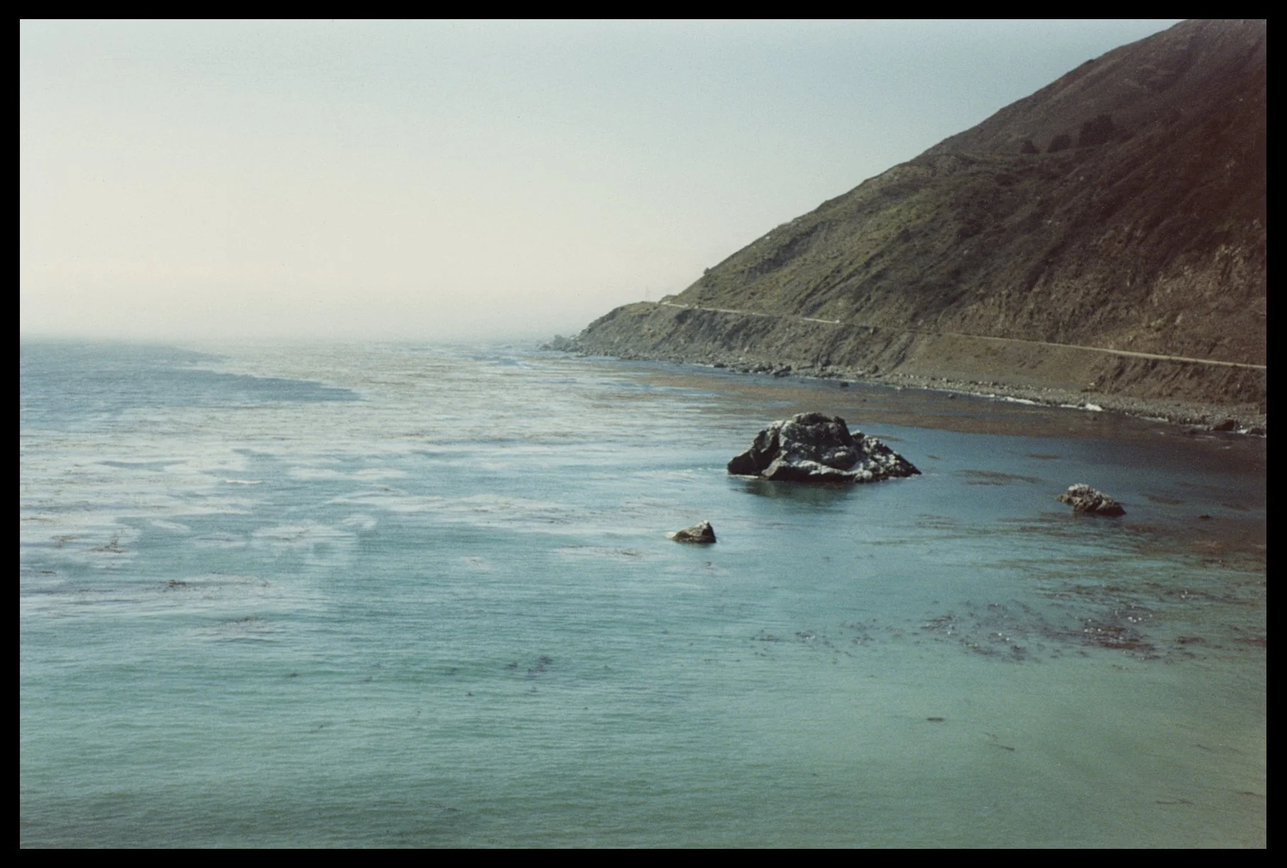
Headland and rocks, Big Sur 1990. Taken from a lookout spot south of Alder Creek. Photo: Ryan B. Anderson.

Big Sur Lookout 1990 (Where it all began)

August 27, 2026

This is the very first photograph that I remember taking in any kind of deliberate sense. I was on a road trip with my mother when I was about 15 years old, so this would have been in 1990. This was taken at a lookout spot just south of Alder Creek. I was using my mother’s Pentax ME-Super with either a 35mm or 50mm lens. This looks more like the 50mm to me. It’s not a particularly sharp image. I was hand-holding the camera and had no idea about things like shutter speed and camera shake. But, looking back, this is basically one photo that I have been basically taking over and over again for decades. Ocean, headland, coast. Here’s what this spot is looking like more recently, via Google maps:
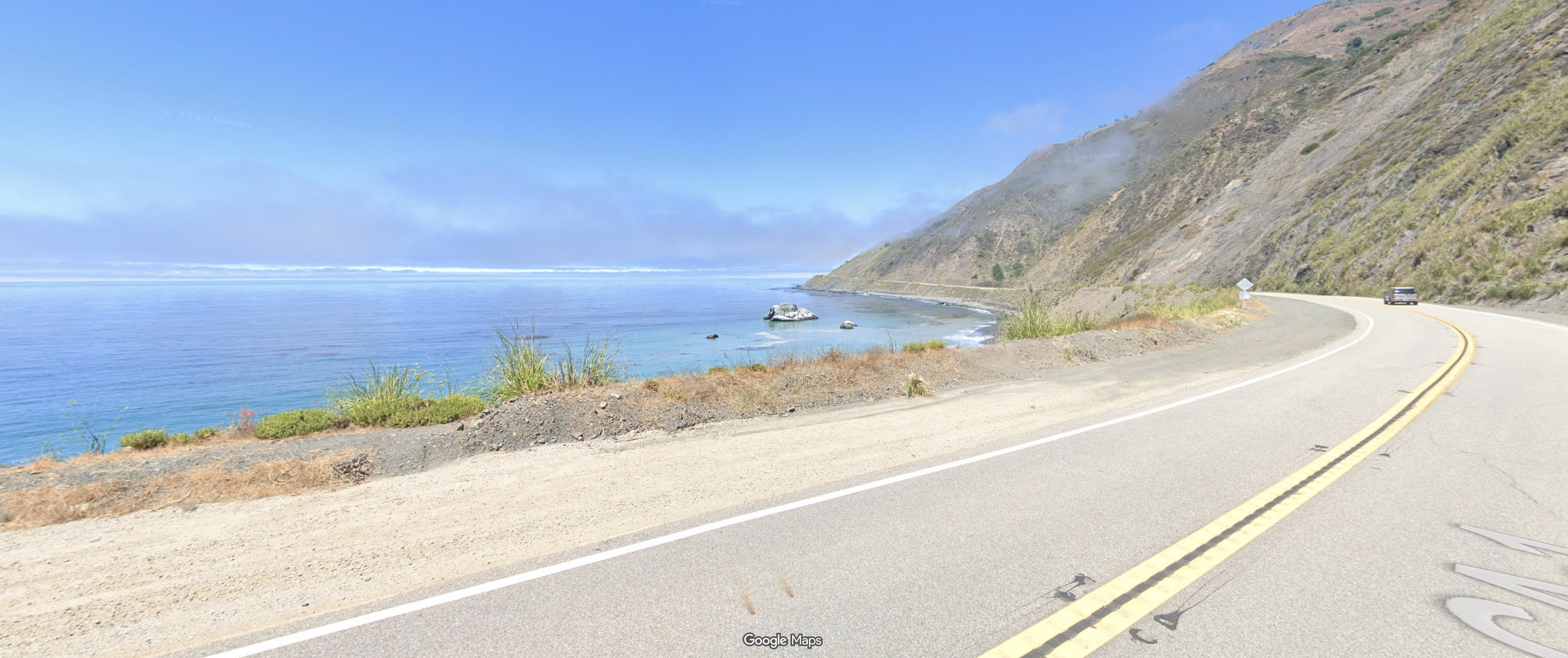
2023 Google maps view of the same approximate location as the 1990 image above.

The Google maps view was taken from a little further north on the road. Mine was taken right from the spot where you pull off the road at the lookout. This will be a fun one to relocate and rephotograph next time I get a chance to head through Big Sur again.

In Coastal Anthropology, Photography Tags California, Repeat photography, Big Sur
Sand loss at Tamarack →

Latest Posts

Featured
Big Sur Lookout 1990 (Where it all began)
August 27, 2026
Big Sur Lookout 1990 (Where it all began)
August 27, 2026

This is the very first photograph that I remember taking in any kind of deliberate sense. I was on a road trip with my mother when I was about 15 years old, so this would have been in 1990. This was taken at a lookout spot just south of Alder Creek. I was using my mother’s Pentax ME-Super with either a 35mm or 50mm lens. This looks more like the 50mm to me. It’s not a particularly sharp image. I was hand-holding the camera and had no idea about things like shutter speed and camera shake. But, looking back, this is basically one photo that I have been basically taking over and over again for decades. Water, headland, coast. Here’s what this spot is looking like more recently, via Google maps:

Read more →
August 27, 2026
Sand loss at Tamarack
August 26, 2026
Sand loss at Tamarack
August 26, 2026

Sometimes it’s a little hard to judge sand loss at a given location. With the sand loss event at Tamarack in Carlsbad this past month, what effectively happened was the return to how the sand and beach looked before the extensive sand replenishment that started in the early 2000s. The image above, which was taken before the seawall was constructed in the late 1980s, shows the beach and parking lot. Notice that the parking lot was already protected by riprap at this time. Here’s another image from after the seawall was constructed (circa late 1980s to early 1990s):

Read more →
August 26, 2026
3A1A7393-The Strand Oside-web.jpg
August 26, 2026
Oceanside Strand in 2019
August 26, 2026
Read more →
August 26, 2026
20260812-444A7730-2BW-web.jpg
August 23, 2026
Tamarack erosion and seawall
August 23, 2026
Read more →
August 23, 2026
Erosion and sand loss at Tamarack State Beach
August 23, 2026
Erosion and sand loss at Tamarack State Beach
August 23, 2026

I took the photograph above back in March 2018 at Tamarack. That was when the beach was full of sand after a relatively recent replenishment. I went back to the same spot during my most recent trip. I couldn’t take a photo from the same location because the sand where I was standing in 2018 was gone. Here’s what things looked like in 2026:

Read more →
August 23, 2026
Tamarack Parking lot in 1959 and 2026
August 22, 2026
Tamarack Parking lot in 1959 and 2026
August 22, 2026

Here’s another photo from my recent trip down the Southern California. I headed down in part because my old home beach of Tamarack was in the news. Check out some of the coverage via the SF Gate here, and NBC7 here.

Long story short, high tides and large waves from a summer south swell swept a lot of sand off the beach at Tamarack. It also undermined the riprap that was protecting the parking lot. In some of the coverage, people express concern about the loss of sand from the beach. Others say that this is how the beach actually used to look years ago.

Read more →
August 22, 2026
California Coast Rephotographic Project: Carlsbad Seawall
August 20, 2026
California Coast Rephotographic Project: Carlsbad Seawall
August 20, 2026

After Tamarack State Beach made the news for losing a bunch of it’s sand in the last couple of weeks, I managed to get down there for a few comparative photographs. The composite above shows a stretch of the seawall that’s at the end of Sycamore Avenue in Carlsbad. This one was pretty easy to relocate and photograph. I found the historical image, which dates to the late 1980s or early 1990s, via the Carlsbad Library:

Read more →
August 20, 2026
IMG_4984-Blacks Beach DEC 2005.JPG
August 9, 2026
Black's Beach, December 2005
August 9, 2026
Read more →
August 9, 2026
CRW_2451_RT8_BW-small.jpg
August 9, 2026
Wilder Ranch in 2005
August 9, 2026
Read more →
August 9, 2026
The Cliff House in SF
August 4, 2026
The Cliff House in SF
August 4, 2026

Here’s another spot I’d like to rephotograph up at Ocean Beach in San Francisco. The photograph above was taken by William Henry Jackson between 1880 and 1910. It’s from the 1974 monograph of Jackson’s work that was edited by Beaumont Newhall and Diana E. Adkins (published by Morgan & Morgan). This is the second Cliff House, so it had to be taken after 1896.

Read more →
August 4, 2026

Powered by Squarespace